FAA's Heliport Location Database May Be Rife With Errors
A key database of heliport locations throughout the U.S. might be rife with errors.


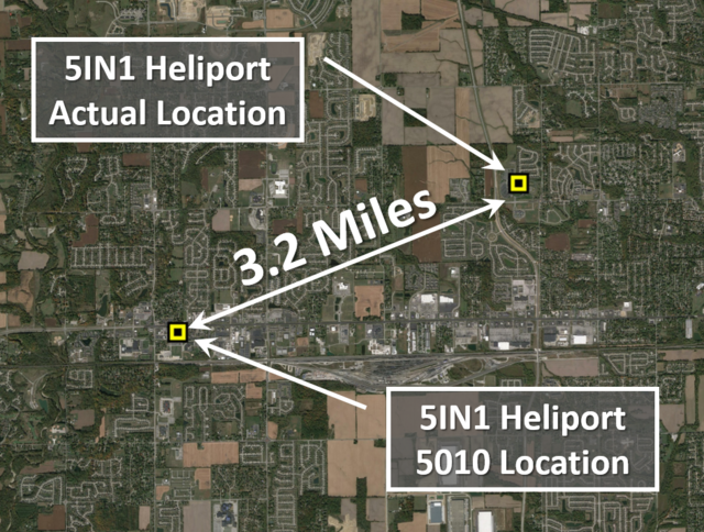
Would it surprise you to learn that one of Northern Ohio’s largest trauma centers, which has three heliports, only has one of those on record with the FAA in its Airport Master Record database?
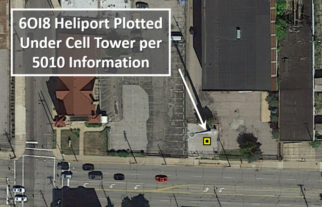
Or that the database’s coordinates for that same heliport are incorrect by some 8/10 of a mile, placing it underneath a cell tower in a church parking lot, and that it has been that way for the better part of 15 years.
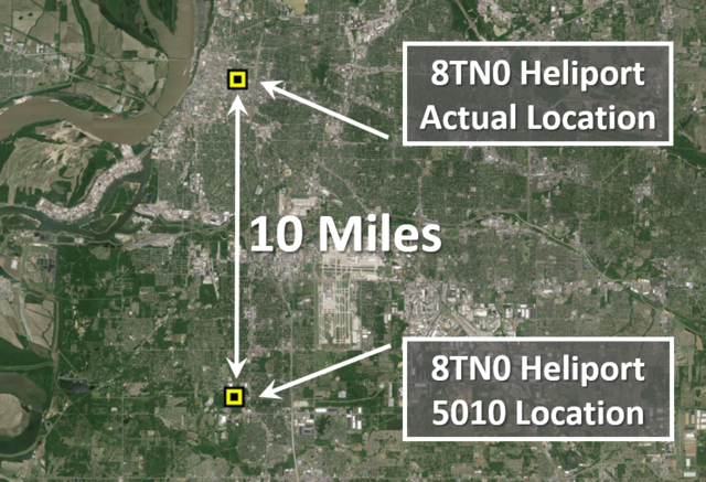
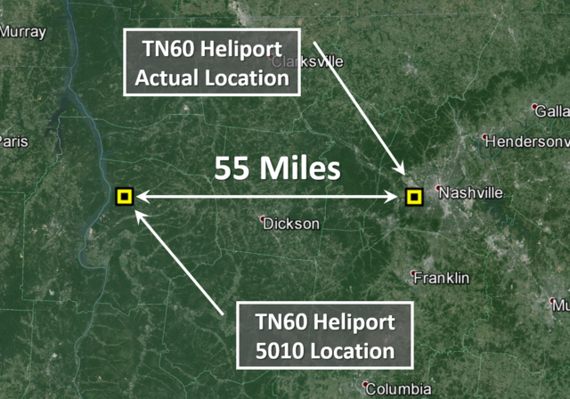
How about the fact that a prominent television station in Nashville, Tennessee, has a heliport that is incorrectly plotted by some 55 statute mi or that a hospital moved its facility to include its heliport some 5 mi away more than three years ago, and it’s not the new ground-based heliport that is in the system but rather the old one that no longer exists?
Currently there are no truly accurate and reliable national databases in existence in the U.S. for “private” PPR (prior permission required) airports and heliports. The majority of databases in existence today, to include the numerous online flight-planning websites and hundreds of GPS cockpit navigation units, pull their information from a single master source, e.g. the FAA 5010 Airport Master Record. When it comes to “private” facilities, that master source, however, has been shown to be based on some very outdated and oftentimes inaccurate information. This is primarily due to the fact that there are no federal regulatory requirements for these facilities to ever have their information re-evaluated or updated by anyone from the FAA or in most cases the residing state Dept. of Transportation once this data has been entered into the system. In almost all cases, the sole responsibility for updating the information for private facilities with the FAA lies entirely with the owner of the facility.
During initial research on the accuracy of the FAA 5010 database in 2015, it was found that in two states alone, the accuracy of whether a heliport actually existed was between 55% and 60%. On top of this, the latitude and longitude coordinates for those heliports that were identified as in existence were found to have an accuracy rate somewhere in the neighborhood of 54% at the time of review. Numerous heliports were as much as 2, 3 and even 5 mi off. If you’re an airplane pilot and are thinking that this does not apply to you, think again. These same inaccuracies are not relegated to just heliports. Numerous private airports around the country have been found to suffer from the exact same fate when it comes to accurate 5010 data.
If you, like many other pilots, are using any of the popular websites, such as those provided by AirNav, Flight Vector, AOPA, Airport-data, CheckAFD, Airport Guide, PilotNav and even the new HEMS Weather Tool, among numerous other nonaviation sites for preflight planning purposes, keep in mind that they all generally pull their information directly from the FAA’s Airport Master Record Database. Hence, any inaccuracies in the FAA’s database are duplicated throughout these sites. To illustrate this point, type in the FAA Identifier of a private facility that you are familiar with into your favorite online search engine, and see just how many
different websites pop up, vying for the opportunity to provide you with the FAA’s information for that location. Now check the accuracy of the data, and if you identify any errors, see just how many sites have the exact same error duplicated on them.
Something even more significant of which every pilot needs to be aware, other than just the online data accuracy, is the fact that several manufacturers of aviation GPS navigation devices are now incorporating this exact same “private facilities” data into their navigational equipment. More importantly, many are advertising to the public that “in the case of an emergency” a pilot need only push the “nearest” button on their GPS console to access all of these newly added “private facilitates.” This, in turn, will provide the pilot with more options in flying to the nearest viable destination during an emergency situation. The fact of the matter is, after the pilot pushes the “nearest” button on his or her GPS receiver, there is a reasonable chance that the system selects a “private facility” as the best nearest option and may inadvertently put him or her in the middle of nowhere—or worse, in the middle of a metropolitan downtown area running out of time, weather, fuel—and ideas.

A new and very challenging wrinkle in the database accuracy puzzle applies to our capability of deconflicting the airspace between manned and unmanned aircraft. For the conscientious drone operator who wants to be safe and in full compliance with both regulatory requirements and good practice guidelines, without accurate data as to the location of “private facilities,” we cannot expect them to know where these facilities are located.
The FAA’s recently released smart phone application “B4UFly,” which is designed to assist both hobbyist and commercial drone operators in identifying where airports and heliports are located, pulls its information from the same database as does all of the above mentioned websites and GPS equipment.
So you may be wondering why or how this system has become so inaccurate. While there is a requirement in the U.S. for all public facilities to be audited and updated on an annual basis, as stated previously, there are no federal requirements or processes in place for the FAA to audit or inspect private facilities once they have been established.
In a nutshell, it all comes down to the fact, at least at the federal level, the FAA is not authorized to exercise oversight over private airports and heliports and that the strict guidelines they must follow for public facilities are only recommendations when it comes to private facilities, which includes updating database information. And, while some states have legislation, which provides for their individual Dept. of Transportation to have some authority in the regulatory oversight of these facilities in their states, there are only a handful of states that have adopted such legislative standards. Therefore, it is left up to the owners of these facilities to police their own actions as they see fit, regardless of the guidance provided by the FAA, which includes updating their facilities information.
The current process, which has failed to achieve a reasonable accuracy level, includes the mailing of information request letters by a third-party government contractor to the airport and heliport owners as listed in the 5010 database. The owner is then responsible for updating the information on the form and returning it to the third-party contractor, who then coordinates with the FAA to update the data in the database. However, there is no requirement for the owner to return the information nor does anyone follow up on the request for information if it is not returned. If the point of contact information is incorrect, the request generally never reaches its intended destination in the first place.
In numerous cases, it was found that the point of contact listed in the 5010 record for “private” facilities had not been associated with that facility for several years. In at least one instance, the individual listed as the point of contact for the facility had been deceased for quite some time. Combine this with all of the incorrect addresses and phone numbers currently associated with the database information, it makes it extremely challenging, if not impossible, for the conscientious drone operator to meet the federal regulatory requirements of notifying the owner of an airport or heliport about operations in the vicinity.
One bright spot of hope on the horizon is a new system that has been created by a company called LZControl. Rather than relying on a third-party government contractor to send mailers to airport and heliport owners that might never be received due to inaccurate contact information or never returned because the recipient didn’t know what it was, LZControl is designed to rely on the end user, or the pilots, to update data. This system approach, combined with a 24/7 online and mobile capability, allows for pilots to update and exchange critical information virtually in real time versus the current 10-, 20- and even 30-year cycle to which we currently are accustomed.
So the next time you are checking the information of a “private” facility on a website for flight-planning purposes, using the nearest function on your GPS during an emergency or using an application to help you stay legal and safe when operating a UAS vehicle, you might want to double check that information before you bet the house on it. At least for thetime being. R&WI