The Gulf of Mexico is a seabed that seems to offer a never-ending supply of crude oil and natural gas, covered by 587,000 square miles of ocean. The oil and gas industry here provides overwater employment for thousands of men and women who keep the product flowing to onshore facilities that make it into usable energy for America’s benefit.
To keep the oil and gas moving, support industries supply needed expertise, such as transportation to and from the work sites. Today, there are facilities over two hundred miles from the beach that hover over 10,000 feet of water and drill into the seabed for another 30,000 feet.
Some 3,000 structures are planted on the seabed, many of them manned by workers who remain there for 14 days at a time, without the comfort of home and family. These personnel are exchanged for a matching group at the end of their stay, and the departing workers are released for a 14-day rest at home.
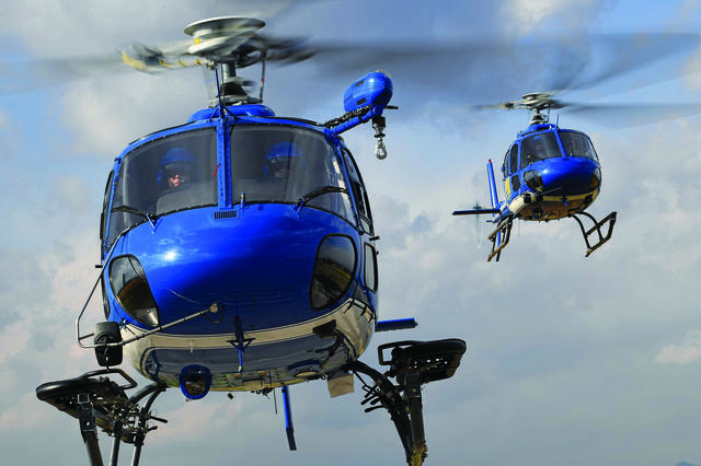
Transporting these workers can be done by either boat or helicopter, the latter being much-preferred. There are currently eight separate helicopter companies with bases scattered all along the Gulf Coast who provide this service.
The Gulf is divided into overlaid sections called “fields,” each given arbitrary names by the United States Geological Survey (USGS) and then further divided into numbered blocks of four square miles each and given an abbreviated name and a number identity tied to the field name. For example, if you want to go to a specific location in the Ship Shoal field, you could route yourself to Ship Shoal 145, where you might find a platform or a helideck with a sign on it reading SS-145.
It has been my privilege to accompany Al Nichols, a senior helicopter pilot with Westwind Helicopters, to several offshore locations. Nichols is also the base manager at Westwind’s location in Cameron, Louisiana. Westwind has additional bases in Abbeville and Houma, Louisiana, with their corporate office located outside of Houston, Texas.
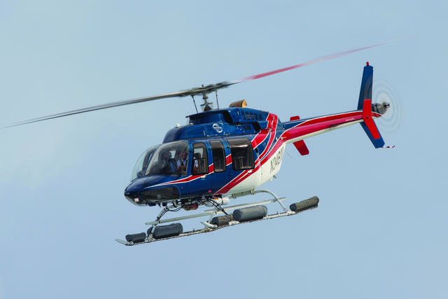
This day’s flight is to be conducted via a Bell 407 helicopter working in the West Cameron and High Island areas of the Gulf. Nichols’ customers are employees of Sanare Energy Partners. Like all personnel who are a part of the offshore industry, he works on a 14-day-on, 14-day-off schedule and is about halfway through his tour. Though he does not remain offshore overnight, he is still required to stay in company housing in the Cameron area. All pilots have to be present for duty, but they can be domiciled anywhere they like and many of them live out of state.
Nichols’ day starts with a scheduling board that assigns him to a specific aircraft and duty. Today’s job requires that he pick up three passengers at an on-shore tank battery and proceed to production facilities in the West Cameron and High Island fields. He then checks the current and forecast weather for these locations and proceeds to the assigned helicopter to conduct a thorough pre-flight inspection, which he ends by topping off the fuel tank. There is a delay due to sea fog on his intended route.
Because I have not flown previously with Westwind, I am required to watch a thorough safety briefing on the Bell 407. The DVD covers all the safety equipment aboard the helicopter with a clear presentation on how to use it. All of Westwind’s passengers view the safety briefing via a DVD and receive any supplemental briefings by the pilot.
After the two-hour weather delay, Nichols starts the helicopter, which is equipped with Full Authority Digital Engine Control, or FADEC, requiring him to mostly just monitor the engine gauges for a clean start. We lift off the helipad and proceed to our pickup point some 15 miles along the coast to the tank battery location, where we meet and load the passengers and their equipment. As with all flights over land and water, there are restrictions and requirements that must be met even though we will be in uncontrolled airspace the whole day. The three passengers are loaded, their equipment stowed and secured in the baggage bay and we head offshore to West Cameron 21 — an offshore platform about 12 miles out.
As we arrive at our destination, we see the helideck is almost covered with roosting pelicans. Nichols sets up the approach and, as we close on the helideck, the pelicans peel off and head for an adjacent platform. Birds can be a problem close to the shore; their droppings often totally obscure the painted markings on the helideck and blank out the solar panels used to charge batteries for the fog horns and other electrical equipment. The helicopter is shut down and the passengers begin and end their work. They reload their equipment and we set off to the next platform. Our new destination will be platform High Island 443, which is 85 nautical miles south of the beach.
Nichols has been busy since before our first takeoff of the day, feeding information into the Sky Connect aircraft tracking system. Using text messaging, both canned and real-time, all phases of the flight are transmitted to the company headquarters in Santa Fe, Texas, including time of departure, destination, number of passengers, fuel on board and estimated time en route. Every time the helicopter starts and the collective is raised, additional information is transmitted showing the helicopter beginning its flight and then sending a position report every 45 seconds below 400 feet and every two minutes above 400 feet. It then shows landing, at which point Nichols sends a text message confirming his touchdown and updating any information needed. The pilot is also responsible for correct customer billing by use of a flight service order, where he records all flight time in minutes.
The flight out is relatively uneventful except for scattered areas of sea fog directly on the GPS heading, requiring several deviations to get around the banks, where visibility is near zero. We will encounter them again on our return flight to the beach.
High Island 443, or HI-443, is permanently manned by Sanare personnel. While the customers are below decks, Nichols looks the helicopter over for general condition and then proceeds down to the deck that holds the living quarters where he can catch up on his paper work and relax, awaiting the return of his passengers. If it is around lunch time, he is welcome to eat with the regular platform crew. The time spent at each platform is never a given; it could be a few minutes or many hours depending on the customers’ need.
On some jobs, a helicopter and pilot are based at the platform and remain there 24/7. This would usually be in support of a large field with many platforms in a defined area. The pilot would be afforded necessary accommodations to include meals and sleeping arrangements, and a system set up to change out the helicopter for maintenance and the pilot for rest. This is not the case for HI-443, as there are only a few platforms here.
Our next stop will be HI-557, another Sanare platform about 20 miles away. This is our refueling site and on this day we will do a “hot fuel,” leaving the engine running. Nichols has radioed ahead on Sanare’s frequency, notifying them of our arrival and how much fuel he needs. Westwind trains customers and qualifies them to do the refueling, giving them a card to verify their qualification. We land, Nichols goes to flight idle and the refueler appears to fill the tank as needed. Westwind positions refueling sites in the gulf at various platforms that will fit with the spread of their customers. Though Westwind owns and maintains 12 offshore fueling sites, there is also the option of borrowing fuel from other helicopter operators if necessary — usually on a pay-back basis.
Our flights have taken most of the day. We begin our return trip to the tank battery to drop our customers and then continue on to the Cameron base. As we progress, Nichols takes the time to explain most of the avionics aboard the helicopter.
Starting at the top of the console is a Garmin G500 flight display with two flat screens. The left screen is a moving map replete with terrain, obstructions, traffic and an overlaid weather picture. The right screen displays flight instrumentation. Below these two screens is a Garmin GNS 430W that supplies the GPS, navigation information and very high frequency radios. Traffic can also be displayed on this screen.
Next is the upgraded L3 Lynx ADS-B IN/OUT transponder. This unit can also provide updated in-flight weather. The audio panel is made by Garmin, and below that is the Sky Connect tracking system. Canned text messages are filled in by the pilot for destination, fuel on board, number of people on board and estimated time en route.
There is also an Appareo Vision 1000 system, part of Westwind’s flight operations quality assurance (FOQA) program, which includes an in-cockpit camera that records all flights, focusing on engine and flight instrument parameters to ensure all Westwind flights are performed in accordance with company safety requirements.
Based on my experience flying in the Gulf — admittedly, more than a few years ago — I thought the equipment aboard this Bell 407 was exceptional, especially considering it is a single-engine helicopter.
During our return trip to Cameron, we once again encounter some sea fog blocking a direct path to the destination. Nichols flies this route a great deal and is familiar with how to use the best heading to deviate around the fog banks, saving the customer flight time and reducing fuel burn. As we approach our destination, Nichols does an engine trend check and makes mandatory radio calls advising of our inbound heading, altitude and landing site. Upon shutting down the helicopter, he does a post-flight inspection and completes his flight service order.
Besides the flight I wrote about here, some of the larger operators in the Gulf use helicopters for other missions, such as crew changes, that require large helicopters like the Sikorsky S-92. The is capable of changing out 18 personnel in one flight. All of them fly on instrument flight rule plans, use two pilots and make instrument approaches to rigs that are over 100 miles out.